
Cold environments and glaciation
விளையாடிக் கற்றுக்கொள்ளுங்கள்
ஆற்றல் சம்பாதிக்க இந்த கேள்விகளுக்குப் பதிலளியுங்கள், பின்னர் மீன் பிடித்து ஆராயுங்கள். கணக்கு தேவையில்லை.
கல்வியாளர்களுக்கு: Cold environments and glaciation (Geography, Physical Geography)-க்கான தயாரான பாட ஸ்லைடுகள், திருப்புதல் குறிப்புகள் — உங்கள் பாடத்தில் அவற்றைப் பயன்படுத்தவும், அல்லது கற்பவர்கள் நேரலை விளையாட்டாக விளையாடும் ஊடாடும் வகுப்பு செயல்பாடாக தலைப்பை இயக்கவும்.
பாட குறிப்புகள்
Cold environments
- Tundra is a biome, usually treeless with mosses, lichens, grasses and dwarf shrubs. Arctic tundra occurs in northern parts of Canada, Alaska and Eurasia; alpine tundra occurs at high elevations. Low temperatures constrain growth for much of the year. Low precipitation does not imply every summer soil is dry: poor drainage above frozen ground can lead to waterlogging. Polar environments include both Arctic and Antarctic settings, with major differences in land, sea, ice and ecology.
- Permafrost is ground at or below 0°C for at least two consecutive years; it is defined by temperature rather than the presence of a particular amount of ice. A seasonally thawed active layer can lie above it. It can thaw under changed conditions. This differs from glacier ice, snow cover or ground that freezes for only one winter.
- Adaptations vary by species: low plant growth can limit wind exposure; rapid seasonal growth uses the short summer; insulation, migration or dormancy can help some animals. Do not suggest every animal hibernates, migrates and has blubber. Cold regions contain living communities and livelihoods rather than empty land.
Three different frozen features
Glacial processes
- Persistent snow accumulation can compact into ice that flows under its own weight. Glacier movement includes internal deformation and, in suitable basal conditions, sliding. A retreating glacier has a shrinking terminus position; its ice can still flow downslope. The Lake District preserves glaciated landforms without a present valley-glacier system.
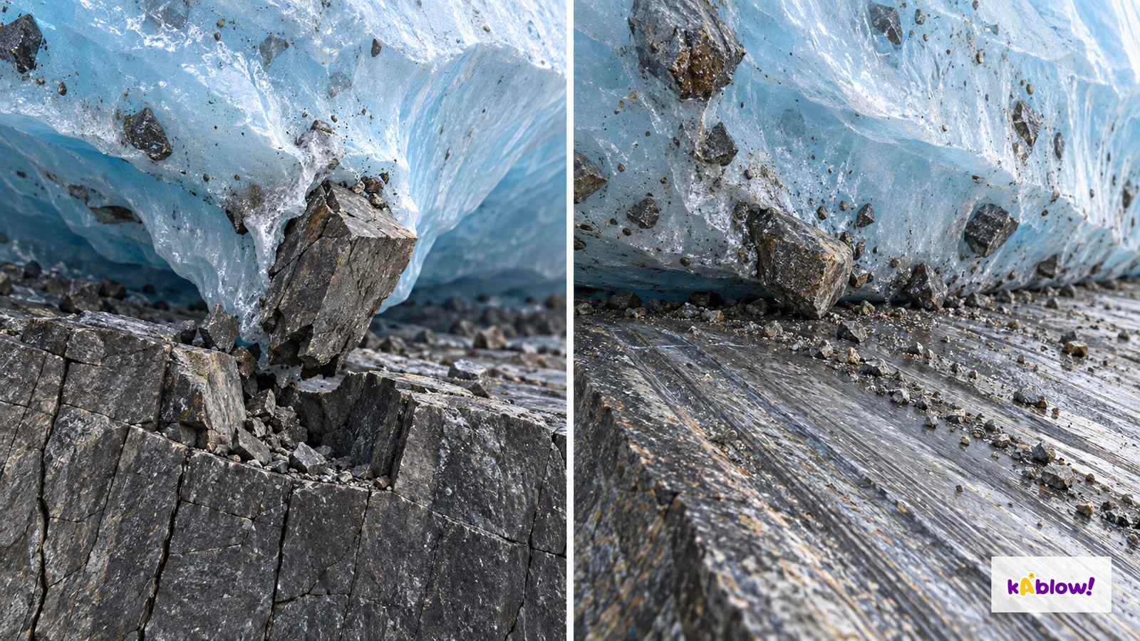
- Freeze-thaw is weathering: suitable repeated freezing can fracture rock in place. Plucking removes loosened blocks as ice moves over bedrock; abrasion occurs when basal debris scrapes and grinds the bed. Their importance depends on ice temperature, water, debris and bedrock structure, so not every glacier erodes at the same rate.
- Glaciers carry debris at the surface, within the ice and at the bed. Direct ice deposition generally gives unsorted till, whereas meltwater can sort and layer sediment. Moraine describes transported and/or deposited debris; lateral belts are at glacier margins, medial belts commonly form where lateral belts join, and terminal moraines mark a former ice margin.
Conceptual glacial erosion
Glacial landforms
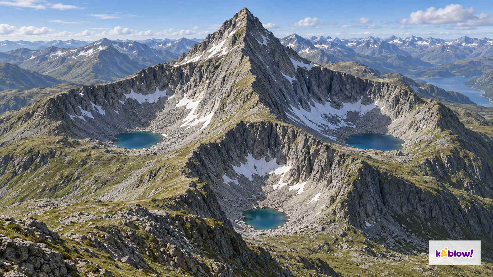
- In a corrie, accumulated ice can rotate and erode an overdeepened basin by abrasion while plucking and weathering help steepen the back wall. A lip remains at the outlet; a tarn may occupy the hollow after ice retreat. Arêtes separate neighbouring eroded hollows or valleys; erosion on several sides can sharpen a pyramidal peak. The imagined composite is not Red Tarn, Striding Edge or the Matterhorn.
- A glacier can deepen and widen a former river valley, truncate spurs and produce a U-shaped trough. Tributary valleys may be left hanging above the more deeply eroded main valley, sometimes with waterfalls. Differential erosion and barriers can retain elongated ribbon lakes. The invented valley scene illustrates geometry without supplying surveyed dimensions or a site identity.
- Moraines are debris belts or ridges, erratics are transported rocks differing from local bedrock, and till is generally unsorted ice-deposited sediment. Drumlins are streamlined hills shaped beneath ice, often aligned in swarms. They are commonly taught as till-deposition landforms, but actual composition can include bedrock or other sediments and their formation is more complex than one universal mechanism.
Imagined corries, arêtes and peak
UK uplands: the Lake District
- The Lake District provides a UK glaciated-upland case study: Red Tarn lies in a corrie near Helvellyn and Striding Edge is an arête. These inherited features do not mean tundra conditions or active valley glaciers persist across the region today.
- Tourism supports spending, employment and businesses, but benefits can be seasonal and uneven. Visitor pressure can contribute to traffic, path wear and habitat disturbance; rainfall and runoff also drive erosion. Housing pressures have several causes, so an undated claim that visitors alone cause higher prices is inadequate.
- Fix the Fells repairs paths and drainage. Reducing sediment washed from damaged paths helps protect rivers, lakes and habitats as well as access. Evaluate ongoing maintenance, appropriate route design, biodiversity and accessible transport. Do not claim a single measure eliminates all erosion or congestion.
Evaluate tourism management
Development in cold environments
- Some cold regions offer mineral, oil, gas, fishing and tourism opportunities. Their availability depends on location and permissions; these are not opportunities at every polar site. Extraction can generate revenue and jobs while creating spill, habitat, infrastructure and greenhouse-gas risks.
- Ice-rich ground can settle unevenly if it thaws, including when heated by structures. Site-specific foundations, insulation or thermal controls can reduce risk; not every pipeline or building uses one identical design. Cold, remote access and slow ecosystem recovery can add costs.
- Evaluate long-term effects and who receives benefits or bears losses. Local and Indigenous communities have knowledge, rights and diverse views; include their participation rather than assuming a single view or treating inhabited landscapes as vacant resources.
ஸ்லைடுகள்
Sign up free to view the lesson slides
Step through every slide for this topic — plus flashcards and revision notes — with a free account.
பயிற்சி கேள்விகள்
இலவச முன்னோட்டம் — 33-இல் 8 கேள்விகள். அனைத்தையும் பார்க்க பதிவு செய்யவும்.
1.What is a glacier?
Easy- Aa large mass of slow-moving ice
- Ba type of rock
- Ca river
- Da lake
2.Which description best fits tundra as a biome?
Easy- Ahot and wet
- Bhot and dry
- Cmild
- Dgenerally treeless, with low-growing vegetation and a short growing season
3.What is freeze-thaw weathering?
Easy- Awind erodes rock
- Brain dissolves rock
- Cwater freezes in cracks and expands, breaking rock
- Dice melts rock
4.What is plucking?
Easy- Awind blowing
- Bice freezes to rock and pulls pieces away
- Crocks grinding
- Dwater dissolving
5.What is abrasion?
Easy- Arocks in the ice scraping the valley
- Bice melting
- Cice freezing
- Dwind blowing
6.What is a corrie?
Easy- Aa ridge
- Ba valley
- Ca lake
- Dan armchair-shaped hollow on a mountain
7.What is a pyramidal peak?
Easy- Aa lake
- Ba valley
- Ca pointed mountain formed by corries on several sides
- Da smooth hill
8.What is a glacial trough?
Easy- Aa lake
- Ba U-shaped valley
- Ca V-shaped valley
- Da ridge
Unlock all 33 questions & more
இந்த தலைப்பிற்கான ஒவ்வொரு கேள்வியையும், ஸ்லைடுகளையும், ஃப்ளாஷ் கார்டுகளையும் மற்றும் திருப்புதல் குறிப்புகளையும் பார்க்க இலவச கணக்கை உருவாக்கவும்.
முந்தைய தேர்வுகள்
இந்த தலைப்பிற்கான முந்தைய தேர்வு பயிற்சி விரைவில் வருகிறது.
விரைவில் வருகிறது