
UK physical landscapes and geology
边玩边学
回答这些题目来赚取能量,然后钓鱼探索。无需账号。
给教育者: 面向 UK physical landscapes and geology(Geography,Physical Geography)的即用型课程幻灯片, 复习笔记——用在你的课堂上,或将该知识点作为学习者可实时游玩的互动课堂活动来运行。
课程笔记
UK relief: regional patterns and exceptions
- Higher ground is widespread in northern and western Great Britain, including the Scottish Highlands, Lake District, Pennines and Welsh uplands. Southern and eastern regions include extensive lower-lying basins and plains, but Dartmoor in the southwest and chalk hills such as the Chilterns show important exceptions. Great Britain is not the whole UK: Northern Ireland includes Mourne granite uplands, basalt landscapes of Antrim and varied lower-lying terrain.
- Many uplands preserve resistant rock, but age, mineral hardness and erosion resistance are different concepts. Sedimentary rocks can form high plateaux and hills. Uplift, structure, glaciation, rivers, weathering, surface deposits and human use all affect relief. Rainfall, soil depth, drainage and agricultural suitability also vary rather than following one north–south rule.
- Ben Nevis is the highest UK summit. Ordnance Survey’s more precise survey changed its mapped whole-metre height to 1,345 m; this was a measurement revision rather than evidence of sudden growth. Maps, cross-sections and named examples are needed for local interpretation beyond a broad relief pattern.
UK regional examples and exceptions
Rock types
- Igneous rock forms when magma or lava solidifies. Granite generally crystallises slowly underground, while basalt commonly forms from more rapidly cooled lava. Crystal size, mineral composition, joints and later weathering affect properties. Do not visually infer coarse granite directly from an erupting lava flow.
- Sedimentary rock includes deposited material subsequently lithified and material precipitated chemically or biologically. Chalk is a fine marine carbonate rock, limestone has several origins, and sandstone forms from sand-sized material. Clay itself can be unconsolidated sediment; claystone is a lithified sedimentary example.
- Metamorphism changes pre-existing rock in the solid state through heat, pressure and associated fluids. Slate and marble are examples; melting and solidification produce igneous rock instead. Rock type is not a universal code for soft/hard, impermeable/permeable or low/high relief.
Classify formation, not landscape height
Weathering and mass movement
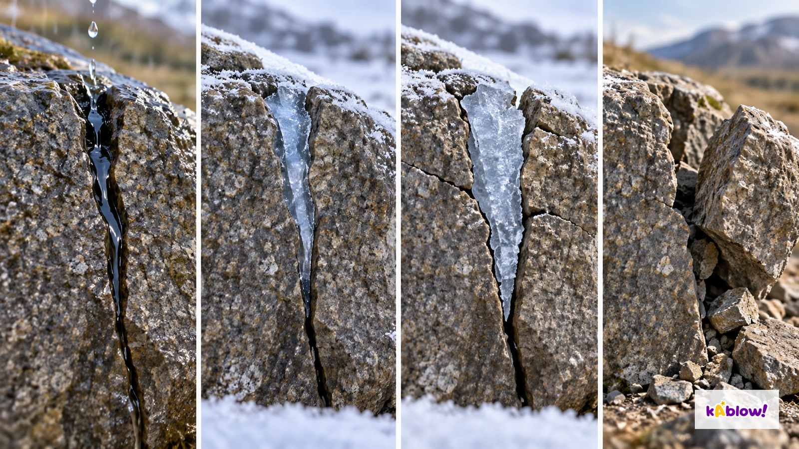
- Weathering acts in place. Physical breakdown includes suitable freeze-thaw processes; chemical alteration includes carbonation of carbonate rock and hydrolysis of feldspar; roots and biological acids can contribute to physical and chemical processes. Carbonic acid in water can react with calcium carbonate, widening limestone joints. Granite also chemically weathers, so do not say it is immune to chemical reactions.
- Erosion removes and transports material by agents such as water or ice. Mass movement is downslope transfer under gravity, including falls, slides, flows and rotational slumps. Weathering can prepare material, but it is not the same as transport. A sequence of frost damage illustrates a mechanism, not an exact number of cycles or a measured time to fracture.
- Rain can increase weight and pore-water pressure, reducing effective stress and shear resistance on susceptible slopes. Geology, joints, slope form, drainage, undercutting, vegetation and human excavation influence stability. Not all landslides occur after rain and not all slopes fail in every heavy-rain event.
Conceptual frost-weathering sequence
Landscape examples
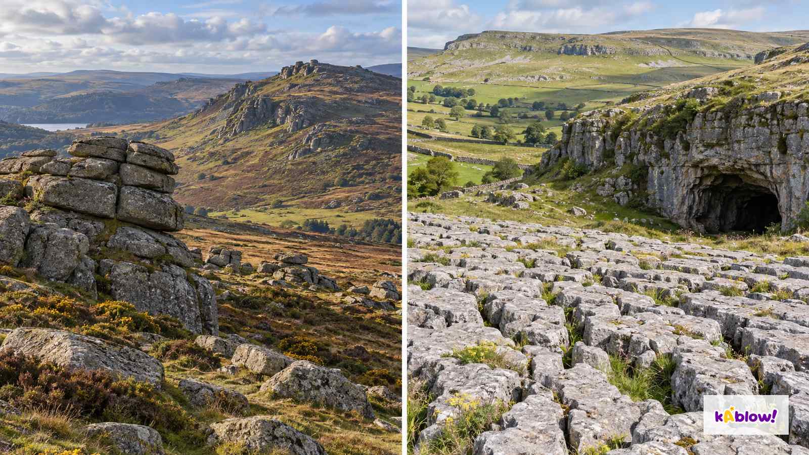
- Dartmoor’s granite tors are prominent residual outcrops shaped by joints, weathering and removal of surrounding weakened material over a long history. They are not simply single blocks made by one overnight frost. The exact balance of deep chemical weathering and later periglacial removal varies among explanations and sites.
- Yorkshire Dales limestone pavements have clints separated by grikes or grykes. Ice can scour and expose limestone surfaces, while later water and carbonate solution enlarge joints. These crevices support distinctive habitats; an imagined landscape is not a survey of a particular pavement or cave.
- The Chilterns show that chalk, a sedimentary rock, can form uplands. Mourne granite provides a Northern Ireland intrusive-rock example. The Dorset and East Devon Coast World Heritage Site, commonly called the Jurassic Coast, includes Triassic, Jurassic and Cretaceous rocks and is not confined to Dorset or to the Jurassic alone.
Imagined tor and limestone landscapes
Human influence
- Farming, forestry, quarrying, reservoirs, roads, settlement and tourism can change vegetation, drainage, slopes and access. Physical conditions constrain options, but economics, technology, land access and policy also shape actual use. Human activity can restore habitats and repair paths as well as disturb them.
- Protected landscapes contain communities, working land and competing uses rather than being universally untouched. Management aims include conserving valued natural and cultural features and supporting understanding and enjoyment, with arrangements differing among places. Evaluate actual pressures, benefits, access, restoration and long-term condition rather than assuming a designation eliminates all change.
幻灯片
练习题
免费预览——33 题中的 8 题。注册即可查看全部。
1.What is the highest mountain in the UK?
Easy- ABen Nevis
- BYr Wyddfa (Snowdon)
- CScafell Pike
- DBen Macdui
2.What is an igneous rock?
Easy- Aone formed from layers
- Bone changed by heat
- Cone from shells
- Drock formed by cooling and solidification of magma or lava
3.Which rock type is chalk?
Easy- Ametamorphic
- Bvolcanic
- Csedimentary
- Digneous
4.Which rock type is limestone?
Easy- Avolcanic
- Bsedimentary
- Cigneous
- Dmetamorphic
5.What is marble?
Easy- Aa metamorphic rock
- Ban igneous rock
- Ca sedimentary rock
- Da mineral
6.What is freeze-thaw weathering?
Easy- Awind erodes rock
- Brain dissolves rock
- Croots push rock
- Dwater freezes in cracks and splits rock
7.What is carbonation?
Easy- Aroots splitting rock
- Bwind eroding rock
- Crainwater dissolving limestone
- Dice cracking rock
8.What is a tor?
Easy- Aa cliff
- Ba prominent residual rock outcrop, often exposed on a hill or ridge
- Ca river
- Da lake
历年真题
该知识点的历年真题练习即将推出。
即将推出