
River landscapes in the UK
खेलकर सीखें
इन सवालों के जवाब देकर एनर्जी कमाएं, फिर मछली पकड़ें और घूमें। कोई अकाउंट नहीं चाहिए।
शिक्षकों के लिए: River landscapes in the UK (Geography, Physical Geography) के लिए इस्तेमाल के लिए तैयार लेसन स्लाइड्स, रिवीज़न नोट्स — इन्हें अपने लेसन में इस्तेमाल करें, या टॉपिक को एक इंटरैक्टिव क्लास एक्टिविटी की तरह चलाएं जिसे आपके शिक्षार्थी लाइव गेम की तरह खेलें।
लेसन नोट्स
The river profile
- A long profile plots river-bed elevation along the downstream course and is often broadly concave, with decreasing gradient. A valley cross-profile cuts across the valley; a channel cross-section is another more local view. Upper V-shaped valleys and broader downstream floodplains are idealised patterns affected by geology, glaciation, tributaries and management.
- Discharge is volume flow per unit time, commonly m³/s; it differs from velocity, depth and total water volume. A large downstream river can flow faster despite a lower gradient because channel efficiency, discharge and roughness matter. The attached long-profile points are explicitly invented teaching data, not measurements of the Tees or another UK river.
Invented river long profile
Processes
- Hydraulic action removes material through flowing-water forces; abrasion uses sediment to wear the bed or bank; attrition wears transported particles through collisions; solution dissolves soluble material. Weathering acts in place and mass movement transfers material downslope, contributing to valley form.
- Traction rolls or slides particles, saltation bounces them, suspension carries fine particles and solution carries dissolved material. Deposition occurs when transport conditions no longer keep sediment moving; grain size, flow and supply matter. A river can erode in one location while depositing nearby rather than switching its entire course into one mode.
Landforms
- Differential erosion of resistant rock over weaker material can produce a waterfall. Plunge-pool erosion, undercutting and collapse can drive upstream retreat and leave a gorge. Other geological controls also form waterfalls and gorges. High Force on the Tees has resistant Whin Sill dolerite over sedimentary layers; glacial meltwater and later river flow helped shape its gorge. The invented waterfall image is not evidence of the exact site geometry.
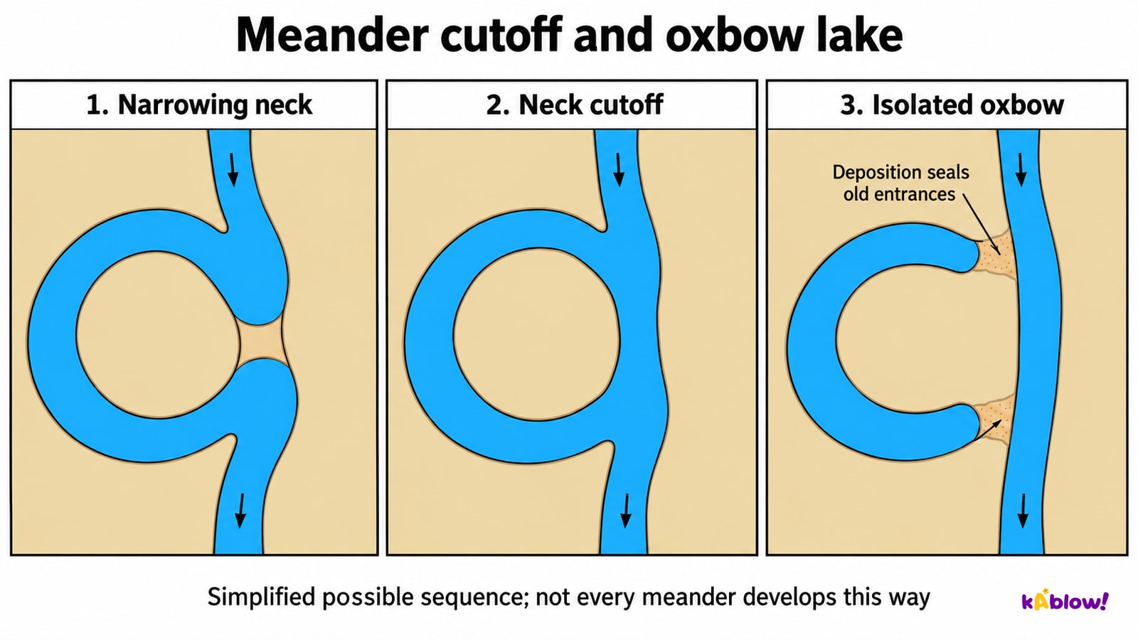
- On a suitable meander, faster and deeper outer-bend flow favours erosion while lower transport competence on the inner bend favours a point bar or slip-off slope. Secondary circulation, sediment supply, bank strength and floods influence movement. Neck cutoff can create a shorter route; deposition at abandoned entrances can isolate an oxbow. Not every meander produces one, and other cutoff mechanisms also exist.
- Floodplains develop through overbank deposition and channel migration. Natural levees build where relatively coarser material is deposited near the channel during overbank floods, with finer material often carried farther across the plain. Built embankments have a different origin. Estuaries are tidal coastal mouths; river mouths can also enter lakes or other rivers.
Meander cutoff and oxbow isolation
Flooding
- Heavy or prolonged rainfall, saturated ground, impermeable surfaces, slope, catchment form and rapid drainage can affect runoff and discharge. Flooding occurs when water exceeds channel, drainage or defence capacities, but actual losses also depend on exposure, vulnerability and warning response. Vegetation change is one factor rather than a universal direct cause.
- A storm hydrograph records discharge through time. Identify rising limb, peak and recession; rainfall may be shown separately with its own units. Here lag is defined as peak rainfall to peak discharge. Other hydrological conventions may use rainfall centroid timing, so state the method and use consistent units.
- The attached synthetic record has discharge observations at 0, 2, 4, 5, 8 and 12 h of 5, 8, 22, 30, 14 and 6 m³/s. Rainfall is stated to peak at 2 h, not plotted as a second quantity on the discharge axis. Peak discharge is 30 m³/s at 5 h, giving a 3 h peak-to-peak lag. It is not a Kendal record or a calibrated flood prediction, and connecting observations does not prove exact between-sample behaviour.
Invented storm discharge record
Flood management
- Dams and reservoirs can retain water if capacity and operation allow; embankments and floodwalls raise local protection levels; straightening can increase conveyance and transfer water downstream sooner. Demountable barriers are also structural defences. Assess habitat, sediment, maintenance, operating requirements, downstream effects and the possibility of overtopping or exceedance.
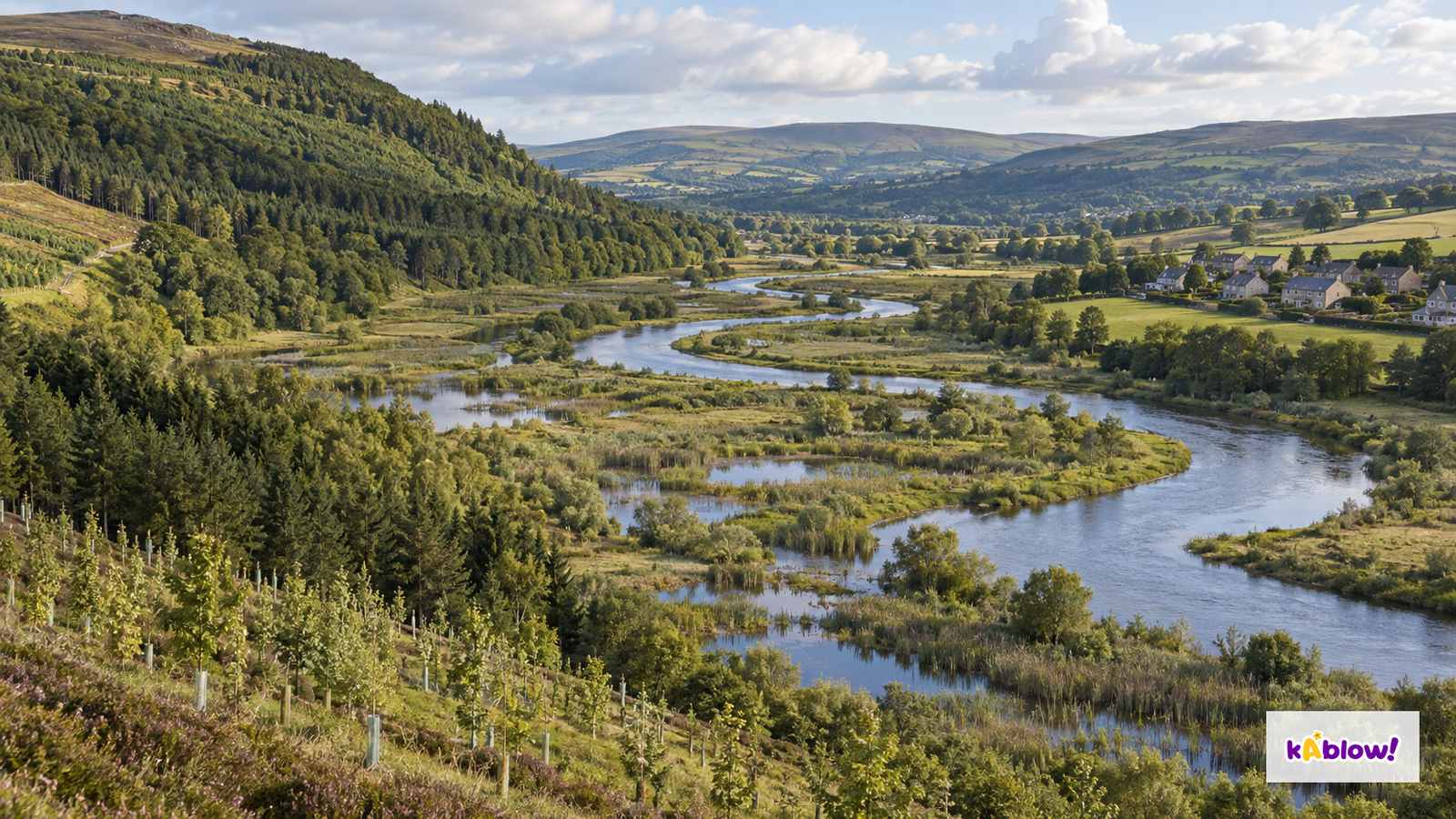
- Warnings and evacuation reduce harm rather than the rainfall or discharge itself. Floodplain zoning limits exposure and needs feasible alternatives and enforcement. Woodland, wetlands and washlands can alter interception, infiltration, roughness or storage, with effects depending on location, soil, season and event size. These measures do not guarantee prevention of every extreme flood.
- Hard and soft are useful GCSE categories but real schemes combine structures, land management and preparedness. Compare lifetime costs and distribution of benefits and losses. A wetland photograph does not measure attenuation, and a local wall may shift risk elsewhere; evaluate connected catchment effects and residual risk.
Imagined woodland and floodplain storage
Case study: a UK river flood (Cumbria 2015, Storm Desmond)
- Storm Desmond caused flooding in Kendal on 5–6 December 2015. The Environment Agency and Cumbria County Council’s 2016 investigation describes prolonged intense rainfall on already saturated catchments and exceptionally high flows in the River Kent and tributaries. About 2,150 properties were directly affected in Kendal; this is a town-specific historical report count, not all-Cumbria homes or a current risk estimate.
- Mintsfeet experienced overtopping when water exceeded defence height. In Sandylands, Stock Beck culvert capacity was exceeded, followed by overtopping of the flood-storage basin. The report also identified surface-water and groundwater mechanisms elsewhere, so not every property flooded by one identical route.
- Recommended investigations included upstream storage, culvert and bridge capacity, modelling, defences, property-level protection and improved warnings. A report recommendation is not proof that each measure has since been built or succeeded. Use the event to explain defence limits and targeted catchment management rather than claiming risk can be eliminated.
Kendal investigation: distinct mechanisms
स्लाइड्स
Sign up free to view the lesson slides
Step through every slide for this topic — plus flashcards and revision notes — with a free account.
प्रैक्टिस सवाल
फ्री प्रीव्यू — 34 में से 8 सवाल। सभी देखने के लिए साइन अप करें।
1.What is a river's source?
Easy- Awhere it begins
- Bwhere it ends
- Cwhere it floods
- Dits widest point
2.What is a river's mouth?
Easy- Aits start
- Bits tributary
- Cits meander
- Dwhere it enters another water body such as a sea, lake or larger river
3.What is erosion?
Easy- Acarrying sediment
- Badding water
- Cwearing away of the land by the river
- Ddeposition of sediment
4.What is deposition?
Easy- Amelting
- Bdropping of sediment
- Cwearing away
- Dcarrying sediment
5.What is a tributary?
Easy- Aa stream or river joining another river
- Ba lake
- Ca waterfall
- Da sea
6.Which process can form a waterfall where resistant rock overlies weaker rock?
Easy- Athe river dries
- Brock dissolves
- Cwind blows
- Dhard rock overlies softer rock, which erodes faster
7.What is a gorge?
Easy- Aa cave
- Ba hill
- Ca deep, narrow, steep-sided valley, sometimes formed by waterfall retreat
- Da lake
8.What is a meander?
Easy- Aa delta
- Ba bend in a river
- Ca waterfall
- Da lake
Unlock all 34 questions & more
इस टॉपिक के हर सवाल, स्लाइड्स, फ्लैशकार्ड और रिवीज़न नोट्स देखने के लिए फ्री अकाउंट बनाएं।
पास्ट पेपर
इस टॉपिक के लिए पास्ट-पेपर प्रैक्टिस जल्द आ रही है।
जल्द आ रहा है