Weather and air masses
Learn it by playing
Answer these questions to earn energy, then fish and explore. No account needed.
Lesson notes
Air Pressure Basics
- Air pressure is the force of air weighing down over a unit of area.
- Pressure is created by the weight of the atmosphere pushing down on the surface.
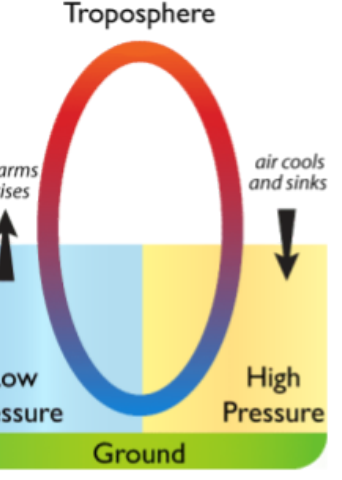
- Heated air rises, creating a low pressure zone; surrounding air rushes in.
- Cooled air sinks, creating a high pressure zone when it reaches the ground.
- Winds are caused by air flowing from high to low pressure; greater pressure difference means stronger winds.
- Warm air holds more moisture than cool air; when it rises and cools, condensation may form clouds and precipitation.
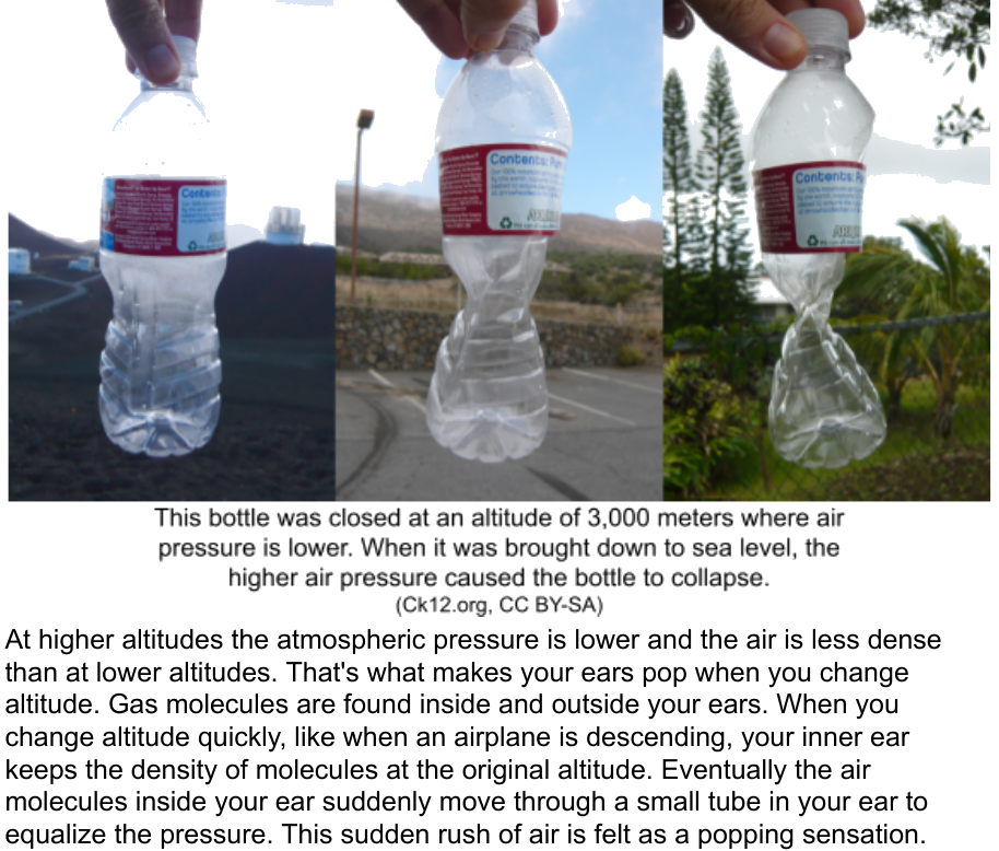
- At higher altitudes, atmospheric pressure is lower and air is less dense.
Diagram of the troposphere showing warm air rising to create a low pressure zone and cool air sinking to create a high pressure zone.
Air Masses
- An air mass is a large body of air with nearly the same temperature and humidity throughout.
- Air mass characteristics depend on where it forms; it must stay over a region for days to pick up those traits.
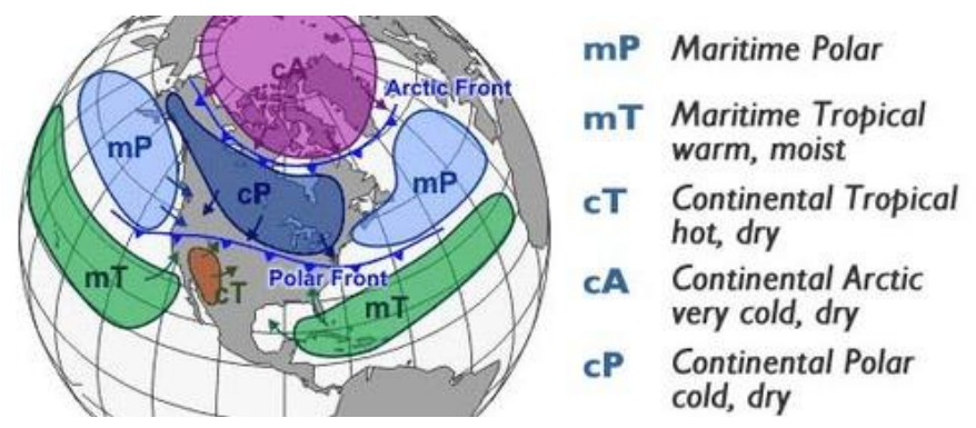
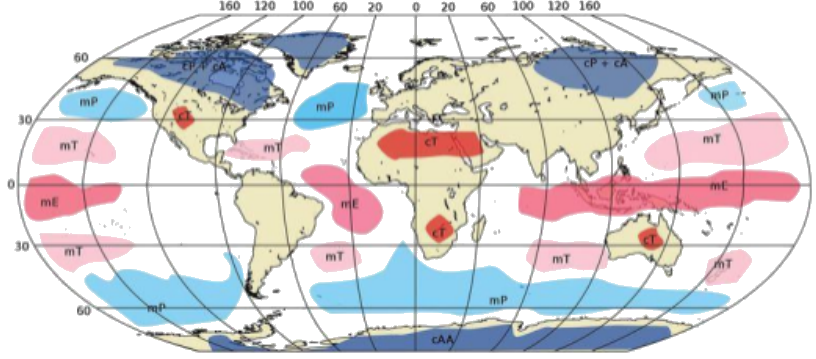
- Most air masses form over polar or tropical regions, over continents or oceans.
- Maritime air masses form over oceans and are moist; continental air masses form over land and are dry.
- Examples: continental polar (cold, dry), maritime polar (cold, moist).
- Temperate zones are too unstable for air mass formation, so they experience varied weather as air masses move through.
Map of North American air masses labelled by type (maritime polar, maritime tropical, continental tropical, continental arctic, continental polar), with the Arctic Front and Polar Front marked.
Movement of Air Masses
- Air masses move due to winds and jet streams.
- Cold air masses tend to move toward the equator; warm air masses move toward the poles.
- The Coriolis effect causes air masses to move on a diagonal; many move northeast over the U.S.
- When an air mass moves over a region, it shares its temperature and humidity with that region.
- Weather changes when an air mass contacts different conditions, e.g., a warm air mass over cold ground may cause an inversion.
Fronts Overview
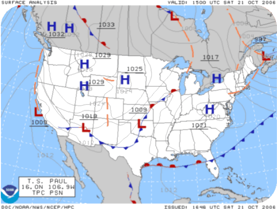
- A front is where two air masses meet; they have different characteristics and do not easily mix.
- At a front, one air mass is lifted above the other, creating a low pressure zone.
- If lifted air is moist, condensation and precipitation occur.
- Winds are common at fronts; greater temperature difference between air masses means stronger winds.
- Fronts are the main cause of stormy weather.
- There are four types: cold, warm, stationary, and occluded.
Cold Fronts
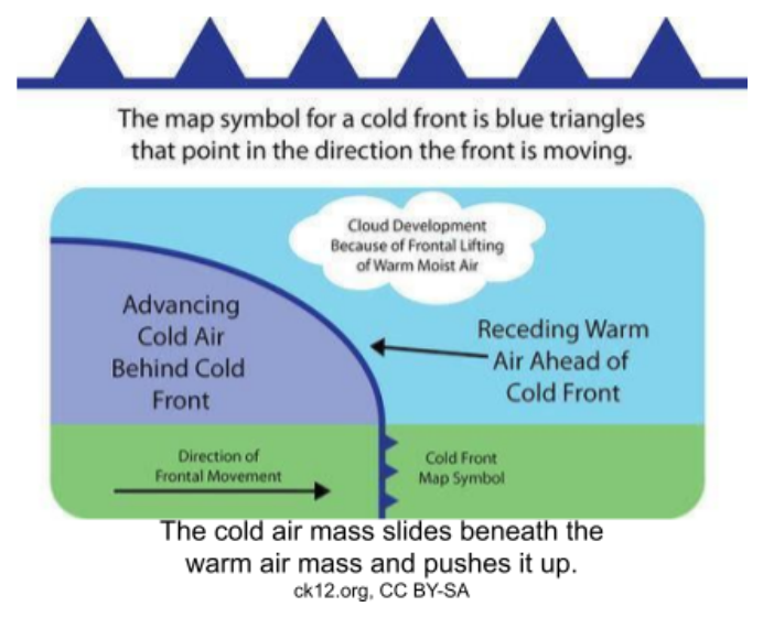
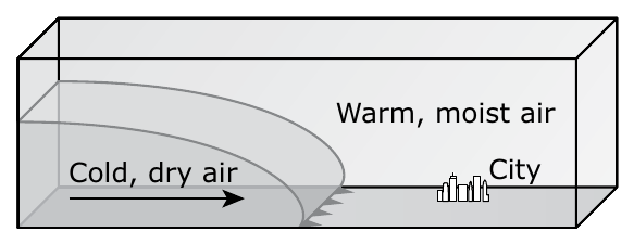
- A cold front occurs when a cold air mass takes the place of a warm air mass.
- Cold air pushes up warm air, causing air pressure to decrease.
- If humidity is high, clouds develop; high winds blow ice crystals from cloud tops.
- At the front: line of rain, snow, or thunderstorms with blustery winds.
- Behind the front: drier, colder air; precipitation stops, weather may be clear or partly cloudy.
- Weather varies by season: spring/summer – thunderstorms or tornadoes; winter – frigid temperatures and heavy snow.
Diagram of a cold front: the map symbol is blue triangles; the cross-section shows advancing cold air sliding beneath receding warm air, lifting it and causing cloud development.
Warm Fronts
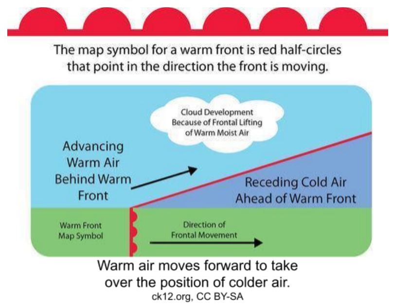
- A warm front occurs when a warm air mass slides over a cold air mass.
- The transition from cold to warm air takes place over a long distance.
- First signs: high clouds appear; then clouds thicken and sky turns gray.
- Precipitation falls as snow in winter, then turns to sleet/freezing rain as warm air approaches.
- Winds strengthen as low pressure approaches.
- Warm and cold air mix at the front, leading to clouds and fog.
Diagram of a warm front: the map symbol is red half-circles; the cross-section shows advancing warm air riding up and over receding cold air, causing cloud development.
Stationary Fronts
- A stationary front occurs when air masses do not move, often stopped by a barrier like a mountain range.
- Stationary fronts can bring days of rain, drizzle, and fog; winds blow parallel but in opposite directions.
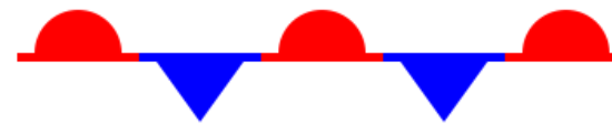
- Map symbol for stationary front: alternating red domes (warm side) and blue triangles (cold side).
The map symbol for a stationary front: alternating red domes and blue triangles along the front line.
Occluded Fronts
- An occluded front forms when a cold front catches up to a warm front; air masses order: cold, warm, cold.
- Weather at an occluded front is fierce with precipitation and shifting winds.
- Map symbol for occluded front: mixed cold front triangles and warm front domes; common on the Pacific Coast.
The map symbol for an occluded front: alternating purple triangles and domes, mixing the cold front and warm front symbols.

Atmospheric Layers and Weather
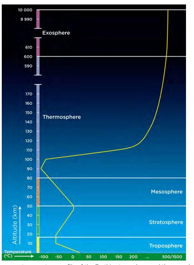
- The troposphere is the lowest layer, extending from sea level to about 9 km at poles and 17 km at equator (avg ~12 km).
- The troposphere contains most of the atmosphere's mass; we live in its bottom part.
- Air in the troposphere is in constant motion due to convection currents, forming the basis for weather.
- All weather systems occur in the troposphere.
- Temperature in the troposphere decreases with altitude about 6.4°C per km.
- The transition zone to the stratosphere is an invisible barrier that prevents moist air from escaping; above it, weather patterns are not found.
Graph of the average temperature profile of Earth's atmosphere and exosphere, plotting altitude against temperature and marking the boundaries of the troposphere, stratosphere, mesosphere, thermosphere and exosphere.
Slides
Sign up free to view the lesson slides
Step through every slide for this topic — plus flashcards and revision notes — with a free account.
Practice questions
Free preview — 8 of 44 questions. Sign up to see them all.
1.What is an air mass?
Easy- AA large body of air with nearly the same temperature and humidity throughout
- BA small pocket of air with varying temperature and humidity
- CA type of cloud that brings precipitation
- DA boundary between two different air masses
2.Air masses that form over oceans are called continental air masses.
EasyTrue or false?
3.Which type of air mass would be cold and moist?
Easy- AMaritime polar
- BContinental polar
- CMaritime tropical
- DContinental tropical
4.Warm air can hold more moisture than cool air.
EasyTrue or false?
5.Which type of front forms when a cold air mass takes the place of a warm air mass?
Easy- ACold front
- BWarm front
- CStationary front
- DOccluded front
6.What is the main cause of stormy weather?
Easy- AFronts
- BHigh pressure zones
- CMaritime air masses
- DContinental air masses
7.At a stationary front, the air masses do not move.
EasyTrue or false?
8.Air pressure is felt only from above.
EasyTrue or false?
Unlock all 44 questions, flashcards & more
Create a free account to see every question, the slides, flashcards and revision notes for this topic.