
Global atmospheric circulation and weather hazards
Learn it by playing
Answer these questions to earn energy, then fish and explore. No account needed.
Lesson notes
Global atmospheric circulation
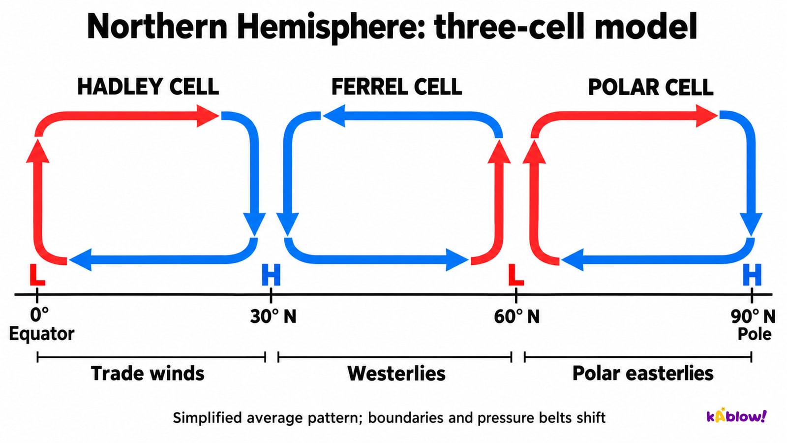
- Unequal solar heating between low and high latitudes contributes to atmospheric and oceanic heat transfer. The three-cell model represents Hadley, Ferrel and Polar circulation in each hemisphere, with approximate boundaries near 30° and 60°. These are average patterns, not fixed walls or identical convection loops. The Ferrel cell is an indirect circulation influenced by surrounding cells and mid-latitude weather systems.
- In the simplified model, rising air near the equator and about 60° is associated with lower surface pressure; sinking air near the subtropics and poles with higher pressure. Subtropical sinking air warms and reduces relative humidity, helping explain many hot deserts. The ITCZ moves seasonally and varies by longitude; pressure belts and rainfall are not fixed on exact latitude lines.
- Trade winds have an equatorward component, mid-latitude westerlies generally blow from the west and polar easterlies from the east. Coriolis deflects motion to the right in the Northern Hemisphere and left in the Southern. The diagram is a vertical section: its horizontal loop arrows show meridional flow, not a complete compass direction for the surface wind. Jet streams are strong upper-level winds that influence weather-system tracks.
Northern Hemisphere three-cell model
Tropical storms
- Tropical cyclone is the general term. Hurricane and typhoon refer to sufficiently intense systems in particular regions: hurricane in the Atlantic and northeast Pacific; typhoon in the northwest Pacific. Tropical storm can also denote a lower wind-intensity category, so these are not interchangeable intensity labels in every basin.
- Warm water around 26.5–27°C through adequate depth commonly supports formation, alongside moist unstable air, a pre-existing disturbance, sufficient rotational influence and low vertical wind shear. Formation is common about 5–30° from the equator but rare exceptions occur. Evaporation supplies moisture; rising air cools and condenses, releasing latent heat that supports convection and circulation. Warm water alone is not enough.
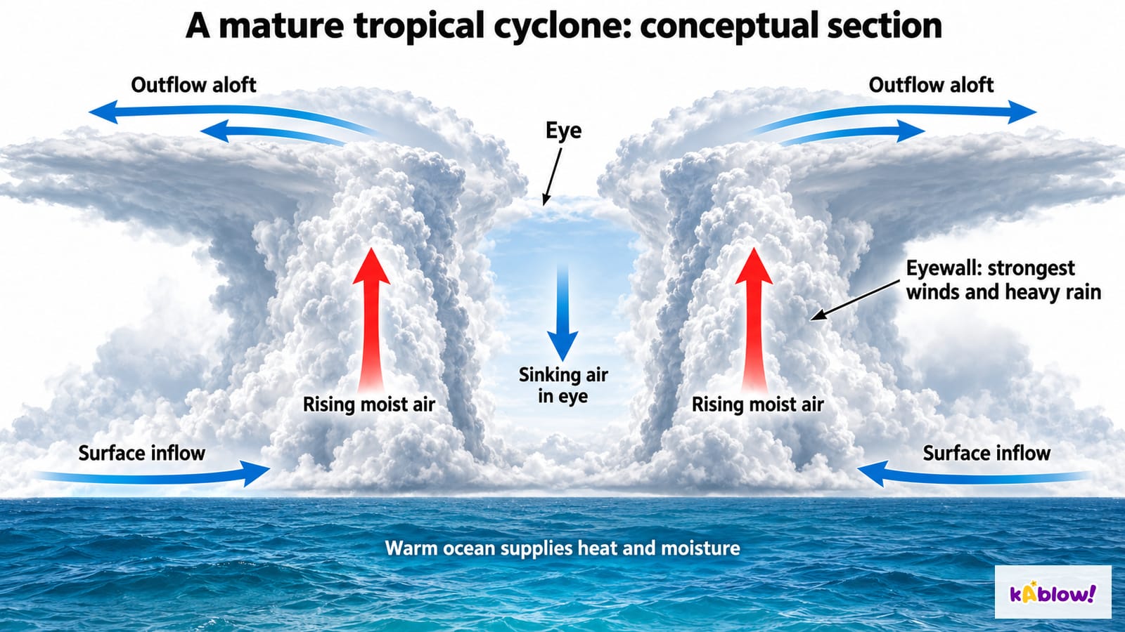
- Many mature cyclones have a relatively calm eye with sinking air, an eyewall with strong winds and heavy rain, surface inflow and upper-level outflow. Not every developing system has an eye. Loss of ocean heat and moisture generally weakens a system over land, while dangerous rain, wind and flooding may continue.
- Storm surge is the abnormal sea-level rise above predicted astronomical tide. Winds are the main driver, with pressure, coastal shape and bathymetry also relevant. Total coastal water levels depend on tides and waves as well as surge; inland rainfall flooding is another pathway. A surge is not a tsunami.
- Haiyan (Yolanda) struck the Philippines in November 2013 with devastating wind and coastal flooding. Katrina in 2005 brought surge and waves and exposed failures in levees and floodwalls around New Orleans. Compare physical hazard, coastal exposure, construction, warning response, access to shelters and inequality. The Philippines is not appropriately labelled an undated LIC, and a high-income country can suffer catastrophic losses.
- Forecasts, warnings, suitable shelters, accessible evacuation, resilient infrastructure and flood defences can reduce risk. Assess uncertainty, communication, trust, transport, maintenance and residual risk. National averages do not describe every household’s ability to act; forecast cones do not bound all possible hazards.
A mature tropical cyclone section
UK weather hazards
- UK weather hazards include windstorms, heavy rain and floods, heatwaves, drought, severe snow and cold. Heavy rainfall can exceed drainage or river capacity, especially with wet antecedent conditions or rapid runoff from impermeable surfaces. Flood risk also depends on exposure, catchment and coastal conditions, infrastructure and defences; it is not a uniform trend at every site.
- The Somerset Levels experienced prolonged flooding during the wet winter of 2013–14, affecting homes, access and agriculture. Evaluate duration, saturated catchments, drainage, river and floodplain management rather than treating it as one isolated rain shower or assuming one intervention can eliminate risk.
- The 2022 hot, dry period illustrates that heat and rainfall deficit can coincide, with different impacts on health, water demand, soils, farming and infrastructure. A drought is relative to expected conditions and system needs, and a heatwave is relative to location and season; one hot day alone does not define either.
- Severe cold and snowfall affected the UK in late February and early March 2018 during the Beast from the East period, with Storm Emma contributing in some areas. Transport disruption and access to services varied by place. Effective preparation needs forecasts, communication, appropriate equipment and support for people at greater risk, rather than a claim that warnings alone prevent every impact.
UK hazards: connect process to impact
Slides
Sign up free to view the lesson slides
Step through every slide for this topic — plus flashcards and revision notes — with a free account.
Practice questions
Free preview — 8 of 33 questions. Sign up to see them all.
1.In the standard three-cell model, how many circulation cells are represented in each hemisphere?
Easy- Athree
- Bone
- Ctwo
- Dfive
2.What is a hurricane-strength tropical cyclone called in the northwest Pacific?
Easy- Ablizzard
- Btornado
- Cmonsoon
- Dtyphoon
3.Which wind blows towards the equator?
Easy- Apolar easterlies
- Bjet stream
- Ctrade winds
- Dwesterlies
4.What pressure is found at the equator?
Easy- Avariable
- Blow pressure
- Chigh pressure
- Dno pressure
5.Which sea-surface temperature is commonly favourable for tropical cyclone formation, alongside other suitable conditions?
Easy- Aabout 27°C
- B5°C
- C15°C
- D50°C
6.What is the Coriolis effect?
Easy- Aa type of storm
- Ba tide
- Can ocean current
- Dthe deflection of winds due to Earth's rotation
7.Why do tropical storms weaken over land?
Easy- Athey gain energy
- Bthe sun is brighter
- Cthey lose their supply of warm moist air
- Dthere are more storms
8.Which area has the strongest winds in a hurricane?
Easy- Athe cloud top
- Bthe eyewall
- Cthe eye
- Dthe outskirts
Unlock all 33 questions & more
Create a free account to see every question, the slides, flashcards and revision notes for this topic.